A research ship can measure ocean conditions for science and collect information useful to a navy on the same voyage. That overlap makes its movements worth examining—and makes those movements difficult to interpret with confidence.
An October study from the Center for Strategic and International Studies analyzes historical vessel tracks and identifies an unusual pattern of Chinese research-ship activity near undersea infrastructure. The security concern is plausible: information about the underwater environment can support operations involving submarines and communications routes.
The study also contains qualifications that deserve to travel with its headline. It examines a selected historical dataset, relies on mapped infrastructure and cannot establish the intent of individual missions. Its findings raise questions about dual use; they do not prove that a particular ship sabotaged a cable.
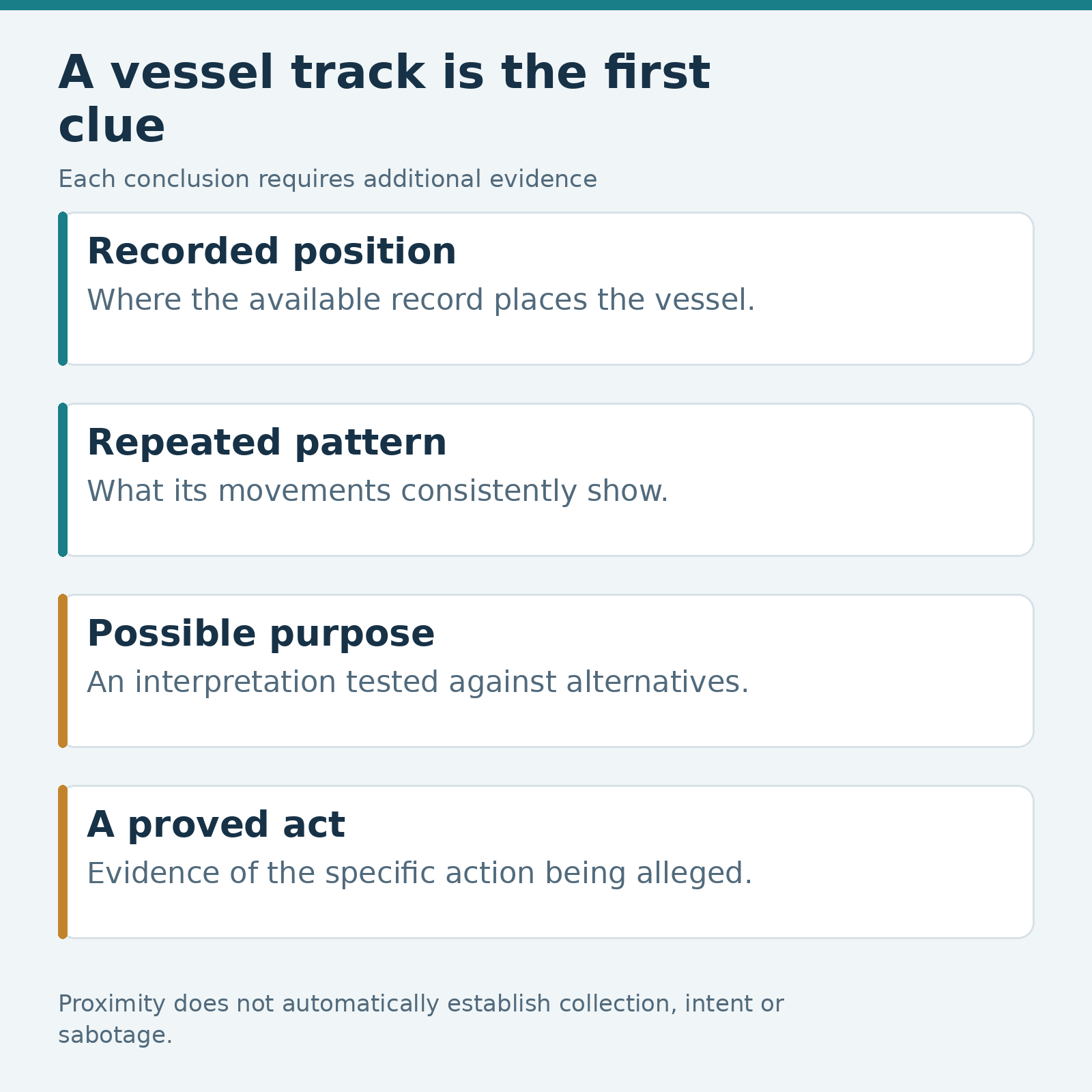
The most useful way to read the evidence is to separate where a vessel went, what pattern its movements formed, what the information could enable and what anyone can demonstrate it actually did.
Ocean science produces strategically useful information
The Chinese Academy of Sciences describes KEXUE as a multidisciplinary research platform equipped for observation, detection, sampling and analysis of the marine environment.
Its account of a 2026 western Pacific expedition describes work on ocean dynamics, climate and geology, using instruments including buoys, moorings, underwater gliders and ship-based surveys. Those are scientific activities with practical research purposes.
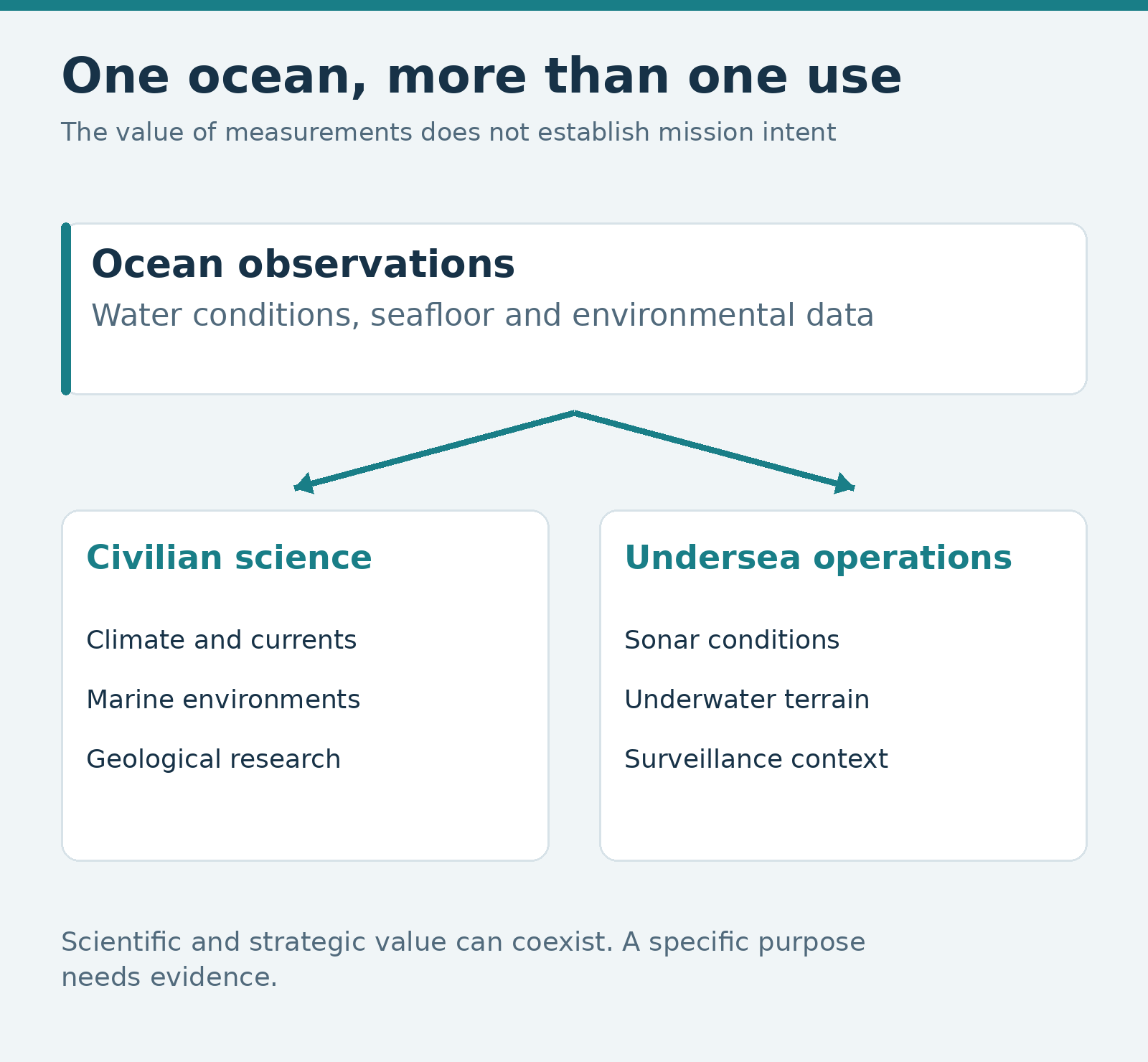
Oceanographic information can also have military value. In testimony published by the US-China Economic and Security Review Commission, Rear Admiral Mike Brookes explained that data such as water temperature, salinity and currents can help optimize sonar performance and support undersea surveillance.
That is the central dual-use problem. A measurement does not lose its scientific value because a navy could use it. Nor does its scientific purpose prevent the resulting information from having military applications.
The difficult question concerns the purpose, handling and eventual use of a particular collection effort. A vessel’s stated mission is relevant evidence, but its existence does not settle every question about its activity. The same caution applies to the opposite conclusion: strategic usefulness alone cannot establish a covert assignment.
What the tracking study actually examined
The full CSIS report uses tracking data for a selected set of 223 vessels over a period running from January 2020 to December 2025. Its analysis associates recorded positions with geographic layers, including undersea infrastructure.
The authors report that Chinese-flagged vessels spent an unusually large share of their observed time near infrastructure on the high seas. Their case studies examine repeated survey-like movements, rather than treating one cable crossing as decisive.
That approach is more informative than circulating a single ship icon beside a cable line. Repeated activity can create a meaningful research question that a momentary encounter would not. The interpretation still depends on the observations available and on how the comparison was constructed.
The report’s methods include a one-kilometer buffer around mapped infrastructure. That is an analytical classification rule. It should not be mistaken for confirmation that a ship found a cable’s exact seabed position or operated equipment directly over it.
The raw commercial tracking dataset was not independently reproduced for this article. The appropriate claim is what the authors found within their method, accompanied by the limitations they disclose.
The Russian cable detail comes from a historical voyage
One of the report’s more unexpected examples involves KEXUE, rendered as Ke Xue in the study. The authors describe survey-like movements near Russia’s Polar Express cable during a northern voyage in 2024.
That detail complicates an easy assumption that Chinese interest would be confined to infrastructure associated with the United States and its partners. It is a useful historical case, rather than evidence of a newly observed deployment in November 2026.
It also illustrates the difference between an observation and the interpretation placed on it. A vessel’s recorded movements near a route can support scrutiny. Describing those movements as intelligence preparation is a further assessment about purpose and potential use.
The article’s publication date and the ship’s movement date answer different questions. Keeping both visible prevents an old voyage from acquiring the urgency of a live incident simply because a new report has drawn attention to it.
A statistically significant association leaves much unexplained
The report’s appendix says its models have low explanatory power. In ordinary language, the flag-state variables explain only a small portion of the differences in observed vessel behavior.
That does not erase the reported association. It limits how much work that association can do. A model can detect a pattern in a group while remaining a poor guide to the purpose of one particular ship on one particular day.
The study’s authors call for additional relevant variables and acknowledge that the results do not independently establish individual mission intent. Readers should resist converting a statistical finding about time near infrastructure into a numerical probability that a vessel is spying or preparing sabotage.
The geographic layers require care too. The case discussions include routes associated with projects at different stages of development. A planned connection is not the same physical object as an operating cable. An apparent encounter must be interpreted against what actually existed at the time of the voyage.
Those are substantive constraints, not technical footnotes. They determine whether a headline describes a security concern, an inferred mission or a proved act.
An AIS gap needs an explanation before it becomes an accusation
Automatic Identification System data can be valuable for reconstructing vessel activity. It is also an information system with inherent limits.
The International Maritime Organization’s published guidance warns that AIS may provide an incomplete picture and that transmitted information can be inaccurate. It also identifies circumstances in which a master may switch the equipment off for safety or security reasons.
Those qualifications do not explain away every suspicious gap. They establish why a gap requires investigation. A public tracking display failing to show a vessel is an observation about the available record. A claim that the crew deliberately hid an unlawful operation goes several steps further.
The same principle applies to a neat grid on a tracking map. Survey-style geometry can be consistent with data collection. The geometry alone does not disclose the tasking instructions, the measurements retained or the organization that eventually receives them.
Additional evidence might narrow the possibilities: a verified mission record, corroborating observations, a documented equipment operation or a well-supported account of the collected data. The confidence of the language should follow the evidence obtained.
Cable faults have a wider background
Security reporting can make an ordinary cable fault look like confirmation of a much larger theory. The background frequency of accidental damage is a useful corrective.
The International Cable Protection Committee identifies fishing and ship anchoring as predominant causes of global faults. It argues that accurate charting helps protect cables by allowing other maritime users to avoid them.
That is not a verdict on any individual incident. A global pattern cannot determine the cause of a particular break. It does mean that an attribution claim should confront plausible ordinary explanations rather than begin by assuming every failure is hostile.
There are also two different questions in play. A study of survey activity asks what information states might be gathering and why that could matter. A cable-damage investigation asks what caused a specific fault. Evidence for one question does not automatically answer the other.
As GripRoom’s Gulf cable-threat explainer discusses, consequences then depend on the networks affected, usable alternative connections and restoration conditions. Even verified cable damage does not establish a uniform outage for every user.
The useful security question is what the evidence can support
Scientific research and strategic preparation can overlap. That creates a legitimate reason to examine persistent vessel behavior near important infrastructure, especially when the information collected could matter during a conflict.
The strongest public account will keep the stages of its reasoning visible. Recorded positions can establish presence. Repeated observations may establish a pattern. Capabilities and context can support an assessment of possible purpose. Proving a specific hostile act requires evidence about that act.
For the Chinese research-ship story, the current public material is strongest on historical patterns and the dual-use value of ocean data. It leaves consequential questions about individual tasking and intent unresolved.
The next persuasive development would add information to that chain: independently reproducible tracks, clearer mission records, verified sensor activity or a properly investigated fault. Until then, a ship passing near a line on a map is the beginning of an inquiry. The quality of the story depends on what can be established after that.
Sources